Maps
SDL Maps gives operators one place to visualize operational entities, add map layers, and inspect geospatial layers published by the local node and by reachable federated nodes. Use it to stream SDM entities, add GeoServer WFS or WMS layers, add TileService-backed map tiles, preview source layers, inspect fetch endpoints, and request that a remote layer be brought onto the current node for disconnected use.
What Maps Shows
The Maps page combines live visualization controls with a searchable inventory of mapping sources.
| Source | What it provides | Typical use |
|---|---|---|
SDM |
Live operational entities from the Semantic Data Model entity stream. |
Plot filtered entity tracks and points on the map. |
Local GeoServer |
Published WFS and WMS map layers from the current node’s GeoServer instance. |
Add live feature layers or raster overlays, preview operational overlays, and inspect fetch details. |
Local tile server |
Raster and vector tile catalog entries from the current node. |
Add basemaps, imagery tiles, and PMTiles or MBTiles-backed map products. |
Remote GeoServer |
Published WMS map layers discovered from federated nodes. |
Use remote overlays while connected, or request federation for offline use. |
Remote tile server |
Tile catalog entries discovered from federated nodes. |
Use remote basemaps or request federation for supported tile packages. |
Remote layers remain dependent on the remote node until you federate them. Federating a layer requests a map transfer to the current node so the layer can continue to operate during disconnected or degraded network conditions.
Open Maps
-
Sign in to the SDL web UI.
-
Open Maps from the main navigation.
-
Use the Visualize, Layer Inventory, or Map Services tab for the task.
If local GeoServer is not configured, Maps displays an information message and continues loading tile catalog entries and any remote endpoints that can be derived from federated node information. If a source cannot be reached, Maps displays an error for that source while still showing layers from sources that loaded successfully.
Visualize Map Layers
The Visualize tab is the default Maps view. Use it to compose a live map from SDM entities, GeoServer layers, and TileService entries.
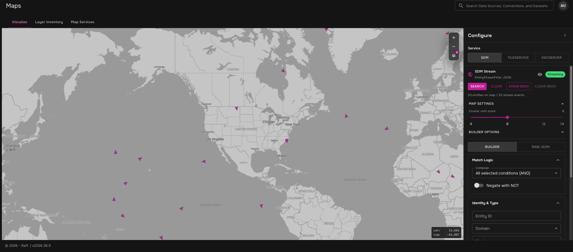
The map occupies the main workspace. The Configure panel on the right selects the active source service:
-
SDM — stream entities from the SDM entity service and render them as clustered points or directional icons.
-
TileService — add tile catalog entries as map tile overlays.
-
GeoServer — add WFS feature layers as plotted map points or WMS layers as raster overlays.
Use the map layer control to show or hide plotted layers, overlay layers, and the default basemap without removing their configuration.
Add SDM Entities
Select SDM in the Configure panel to stream entities from SDM. The panel shows stream status, entity count, event count, filter controls, and cluster settings.
Use the SDM controls to:
-
Click Search to apply the current filter and show the SDM layer.
-
Click Draw bbox to draw a bounding box on the map and add it to the SDM filter.
-
Use Builder for guided filter construction or Raw JSON for direct
EntityStreamFilterJSON. -
Adjust Cluster until zoom to control when dense SDM points split into individual markers.
-
Click the visibility icon to hide or show the SDM layer.
SDM streaming requires a spatial scope. Maps starts the stream when one of these is available:
-
A drawn SDM bounding box.
-
One or more AOI regions on the map.
-
A viewport-derived bounding box from the current map view.
-
An explicit bounding box in the applied SDM filter JSON.
If the filter was handed off from a mesh transfer workflow, Maps displays the delivery intent so the operator can confirm which transfer result is being shown.
Add TileService Layers
Select TileService to browse tile-backed map products from the local tile catalog.
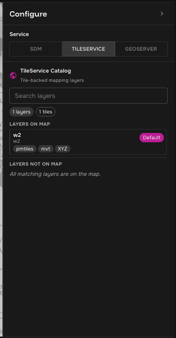
Each catalog card shows the tile name and metadata such as storage type, tile format, and access pattern. Click the visibility icon beside a tile entry to add it to the map or hide it.
TileService entries render as raster map overlays. The default basemap appears in the layer list so operators can hide or show it, but it is not added as a duplicate overlay.
Add GeoServer Layers
Select GeoServer to browse layers exposed by GeoServer.
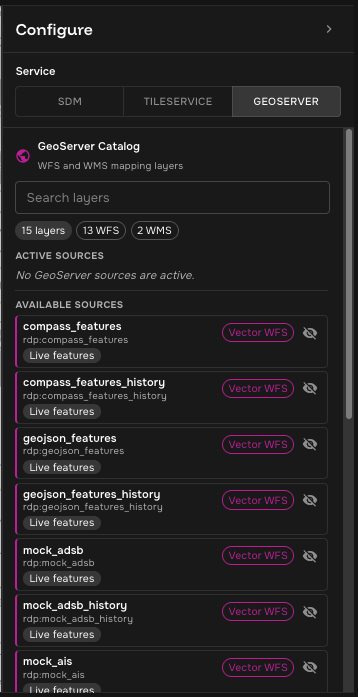
GeoServer layers can be added in two modes:
-
Vector WFS — fetches GeoJSON features from GeoServer WFS and plots them as point markers.
-
Raster WMS — adds a WMS tile layer as a raster overlay.
For active WFS layers, expand Settings to control:
-
Polling Interval — how often Maps refreshes the WFS layer.
-
CQL Filter — optional GeoServer CQL expression applied to the WFS request.
-
Max features — optional cap on returned features.
-
Icon rotation — rotates directional icons using movement between polls when heading is available.
-
Viewport bounding — limits follow-up WFS requests to the visible map area unless AOIs are present.
Maps performs a broader first WFS request so it can detect useful fields such as the feature identifier, geometry field, and time field. Later polls request a smaller field set and can apply viewport or AOI bounds.
AOIs and Bounds
AOI regions apply to live WFS layers and the SDM stream. When an AOI exists, Maps uses AOI bounds instead of the current viewport for scoped live requests. Creating, deleting, or resizing an AOI triggers a new fetch for visible live layers.
Viewport bounding is useful when a layer contains many features. After the first WFS poll, Maps watches for significant map movement and fetches new data when the visible bounds change enough to matter.
Layer Inventory
The Layer Inventory tab is the source discovery and endpoint inspection view. Each row represents one published map layer or tile catalog item.
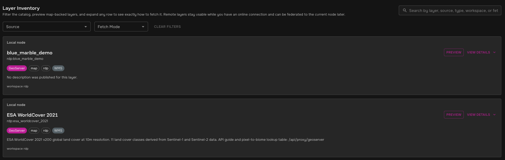
Use the inventory controls to narrow the list:
-
Search — match by display name, canonical name, source, node, workspace, layer type, fetch mode, or metadata.
-
Source — filter to a specific local or remote GeoServer or tile server.
-
Fetch Mode — filter by protocols and access patterns such as
WMS,TileJSON,XYZ, orMapStyle. -
Clear Filters — reset search and filters.
Each layer card includes:
-
Location — local node or federated node label.
-
Display name — user-friendly layer title when published by the source.
-
Canonical name — source identifier, such as a GeoServer layer name or tile catalog name.
-
Badges — source type, render type, storage type, workspace, and available fetch modes.
-
Description — source-published description when available.
-
Metadata — operational details such as workspace, bounds, zoom range, storage type, or tile type.
Preview a Layer
Click Preview on a layer card to open an interactive map preview. The preview lets you validate that the layer renders before using its fetch endpoints or requesting federation.
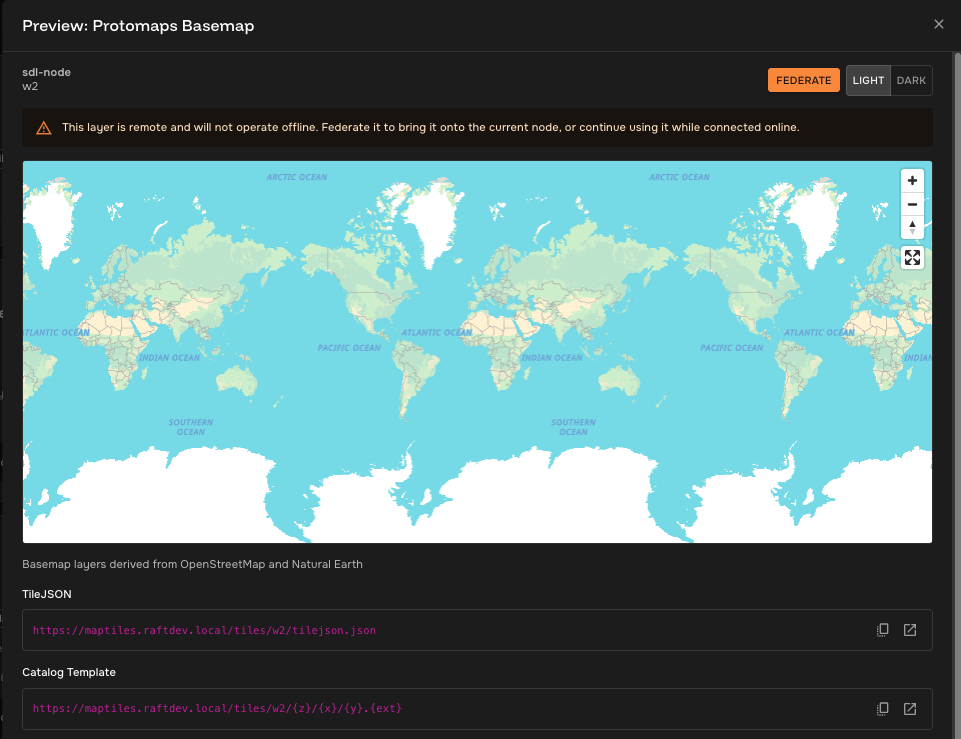
Preview supports:
-
GeoServer WMS layers.
-
Raster tile sources.
-
TileJSON sources.
-
Vector tile sources rendered through the map style service.
For vector tile sources, use the Light and Dark controls in the preview dialog to switch the style theme. For remote layers, the preview dialog also shows a warning that the layer depends on remote connectivity until it is federated.
If a preview fails, Maps shows the preview error and, when available, a sample tile request URL. Use that URL to confirm whether the browser can reach the source service.
View Fetch Details
Click View Details on a layer card to inspect service endpoints. Maps shows the exact links needed to fetch that layer from its source.
GeoServer layers commonly include:
-
WMS GetCapabilities — service metadata for map rendering.
-
Example WMS GetMap — example map image request for the selected layer.
Tile catalog layers commonly include:
-
Style JSON — style endpoint for vector tile rendering.
-
TileJSON — metadata endpoint with bounds, zoom range, attribution, and tile templates.
-
Catalog Template — raw tile URL template published by the tile catalog.
-
Resolved Preview Source — tile source used by the preview.
Use the copy button beside an endpoint to copy it to the clipboard. Use the open button to inspect the endpoint in a new browser tab.
Federate Remote Layers
Remote layers are marked as federated and include a Federate action when they support transfer to the current node. Use federation when a layer is operationally relevant and needs to remain available during DDIL conditions.
-
Find the remote layer in Layer Inventory.
-
Click Preview to confirm the layer is the one you need.
-
Click Federate from the layer card or preview dialog.
-
Wait for the transfer request confirmation.
-
Return later or refresh the inventory after the transfer completes.
Maps can request federation for supported GeoServer layers and tile packages.
For tile packages, the source must publish a supported storage type such as mbtiles or pmtiles.
For GeoServer layers, Maps sends the source workspace and layer name to the current node’s federation service.
| Federate requests a transfer; it does not guarantee immediate local availability. Transfer completion depends on node connectivity, source size, priority, and federation service status. |
Map Services
The Map Services tab shows source-level service endpoints for each local and remote node that Maps can inspect.
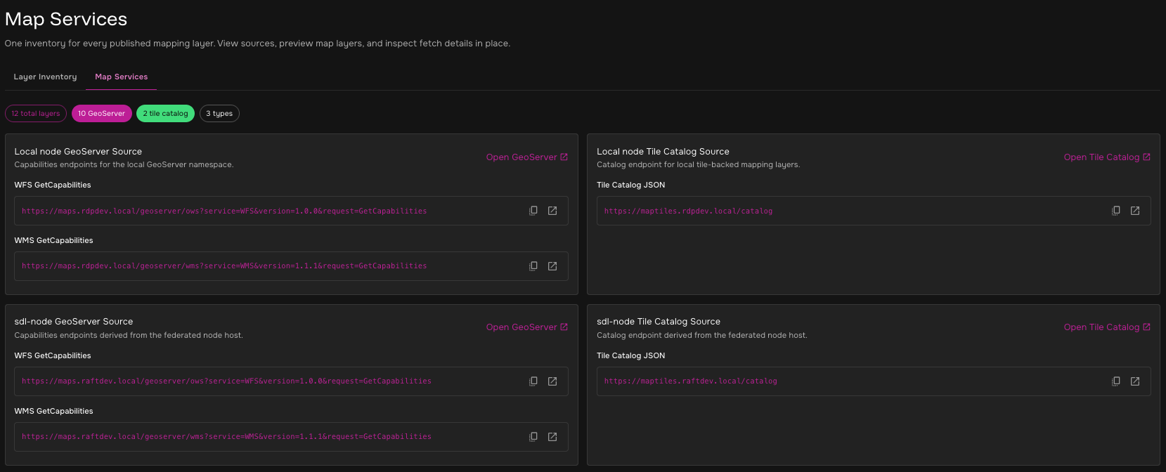
Use this tab when you need to troubleshoot source discovery or provide service URLs to another operator:
-
GeoServer Source — WFS and WMS capabilities endpoints for a node’s GeoServer service.
-
Tile Catalog Source — tile catalog JSON endpoint for a node’s tile server.
-
Open GeoServer or Open Tile Catalog — opens the source service directly.
The summary chips show total discovered layers, GeoServer layers, tile catalog layers, type count, and federated layer count.
Local and Remote Behavior
| Layer location | Online behavior | DDIL behavior |
|---|---|---|
Local layer |
Preview and fetch from the current node. |
Remains available as long as the local map service is running. |
Remote layer |
Preview and fetch through the federated node’s service endpoint. |
Not available if the remote endpoint cannot be reached. |
Federated remote layer |
Transfer is requested from the remote node to the current node. |
Intended to become locally available after transfer completes. |
For remote layers, Maps derives service endpoints from the federated node URL.
For example, the current node’s tile catalog and style services map to corresponding maptiles and mapstyles service hosts on the remote node.
GeoServer endpoints are derived from the configured local GeoServer URL when possible.
Troubleshooting
| Symptom | Likely cause | Operator action |
|---|---|---|
Local GeoServer message appears. |
GeoServer base URL is not configured for the current node. |
Continue using tile catalog sources, or ask an administrator to configure the GeoServer base URL. |
Source error appears. |
GeoServer capabilities or tile catalog request failed. |
Open the source endpoint from Map Services and confirm the service is reachable. |
No layers match. |
Search or filters are too narrow, or no source returned layers. |
Click Clear Filters and review source errors. |
Preview error appears. |
Browser cannot load the selected WMS, TileJSON, style, or tile endpoint. |
Open the endpoint shown in the preview error or layer details. |
Federate is disabled. |
The remote source does not expose transfer metadata supported by Maps. |
Use the layer online, or contact an administrator to confirm map transfer support for that source. |
Transfer request fails. |
Current node could not create a map transfer request for the remote node. |
Confirm federation health, remote node reachability, and user permissions. |
Related Information
-
DDIL & Edge Operations explains why local availability matters during degraded connectivity.
-
Geospatial Pipelines explains how pipelines publish raster COGs and GeoJSON layers for map services.
-
GeoServer Layer Management Guide describes GeoServer platform services for administrators and developers.